 The central Pacific was still cooler than normal in January,
but it’s warming, and national climate experts say they are seeing clear signs
of a returning El Nino by mid-year.
The central Pacific was still cooler than normal in January,
but it’s warming, and national climate experts say they are seeing clear signs
of a returning El Nino by mid-year.
For Hawai`i, that potentially means drier conditions during
the wet season, and more and stronger hurricanes during the hurricane season.
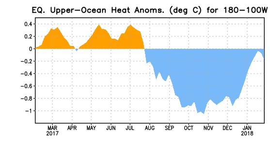
(Image: This chart shows how water temperature at the Pacific
equator differed from normal over the past year. The big blue area at right
represents the cooler water associated with the La Nina that seems to be
ending. Credit: NOAA.)
The warming trend was documented in the latest report today
(Feb. 8, 2018) from the Climate Prediction Center, National Centers for
Environmental Prediction, National Weather Service and the International
Research Center for Climate and Society.
The report confirmed that, for now, La Nina conditions are
still in place, which forecasts in Hawai`i wetter weather and fewer named
storms. For the Mainland, it suggests warmer weather and less rain across the
southern states and cooler temperatures and more precipitation across the north.
“The atmospheric conditions over the tropical Pacific Ocean…
reflected La Niña, with suppressed convection near and east of the
International Date Line and enhanced convection around Indonesia. Also, the low-level trade winds remained
stronger than average over the western and central Pacific, while upper-level
winds were anomalously westerly.
“Overall, the ocean and atmosphere system remained
consistent with La Niña,” the report said.
But most of the climate models used in the tracking of El
Nino-La Nina cycles predict the mild warming seen in January will strengthen
through the next few months, leading to neutral conditions by the period from
March to May, and to full El Nino conditions by fall.
The report says that the various computerized models that
predict climate trends don’t all agree with the forecast, but that on average,
they clearly suggest the warming trend.
The way in which La Nina and El Nino impact storm formation
in the Pacific is complex. In terms of La Nina, here’s what NOAA said in a 2016
statement.
“La Niña typically
suppresses central Pacific hurricane activity by increasing the wind shear and
causing an irregular sinking motion in the atmosphere, both of which suppress
storms from forming and intensifying.”
That was in place during the 2017 hurricane season. There were
actually more storms than normal last year—18 named storms, 9 of which were
hurricanes—but most were weak and did not last long.
But during the last active El Nino, the Pacific was a hotbed
for tropical cyclones big enough to get names. In the El Nino year of 2015, there
were 26 named storms, of which 16 were hurricanes. Hawai`i was spared a direct
hit that year.
It was the second most active hurricane season on record. The
last time there was more hurricane activity in the Pacific was in 1992, the
year Hurricane Iniki hit Kauai head-on.
This latest El Nino-La Nina climate report updates the one we published last month.
© 2018 Jan TenBruggencate


