Hawai’i has benefitted in recent years from the lack of strong hurricanes, while the folks on the Atlantic coasts have taken multiple hits from big spinning storms.
Tropical storm activity can be cyclical. Sometimes it’s higher in the Atlantic; sometimes in the Pacific. That seesaw pattern has been linked to the El Nino Southern Oscillation, a climate pattern associated with ocean water temperature, air temperature, jet streams and rainfall patterns.
During El Nino events, warm water pushes into the eastern Pacific, and tropical cyclones are more likely and stronger in the Pacific. They call El Nino the warm phase. In La Nina, those waters are cooler, and the storm action moves into the Atlantic. They call it a cool phase.
Currently, we’re in a neutral period, but NOAA says we’re likely moving into another La Nina.
Back in May 2024, the National Weather Service predicted a
lower-than-normal hurricane season for the Islands, anticipating that shift from
neutral to a cooler phase. In a May 21, 2024 press release, NOAA reported:
“Hurricane season in the central Pacific region is likely to be below average this year,” said Matthew Rosencrans, lead seasonal hurricane forecaster at NOAA’s Climate Prediction Center, a division of NOAA’s National Weather Service (NWS). “A key factor influencing our forecast is the predicted arrival of La Nina this summer, which typically contributes to less tropical cyclone activity across the central Pacific Ocean basin.”
So far, only Hurricanes Gilma and Hone, at the end of August, came near enough to Hawai’i to cause significant weather events locally.
Meanwhile, the Atlantic has been ravaged, pretty much as predicted.
Nine hurricanes in the Atlantic so far this year, four of them Category 4 or greater. The Eastern U.S. has been hit by two powerful and destructive cyclones in just the past month: Helene and Milton.
And the continuing transition into another La Nina does not bode well for the Atlantic coastlines.
With two months to the end of the hurricane season, Hawai’i can hold its breath with a little hope. A storm might come, but it’s less likely than average.
So what about next year? The latest NOAA El Nino forecast suggests the incoming La Nina will last into the beginning of next year. Beyond that, it’s hard to know what will happen.
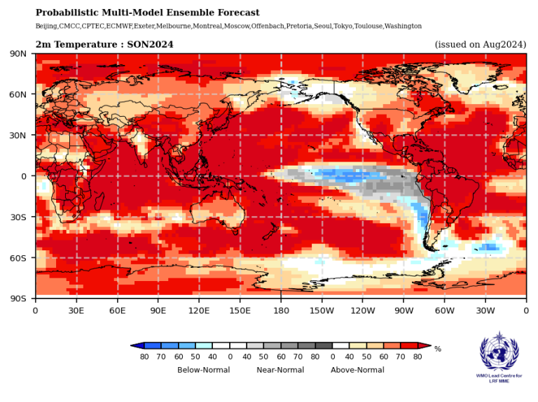
But all this is playing against a background of significant climate warming. The World Meteorological Organization notes that El Nino/La Nina is not the only climate driver. It is predicting warmer temperatures over all land areas and all oceans, besides the La Nina-impacted eastern Pacific.
As you’ll see from the World Meteorological Organiation chart below, that cooler weather is south of the Hawaiian Islands. Like most of the rest of the globe, we in the Hawaiian Islands have warmer than normal weather likelihood.
The WMO also suggests rainfall for Hawai’i will likely be lower than normal from September through November 2024.
Hotter and drier. Welcome to the future.
© Jan TenBruggencate 2024


No comments:
Post a Comment