Showing posts with label Oceanography. Show all posts

Wednesday, March 19, 2025

More and worse than ever: World Meteorological Organization new climate report

 There are those—some of them in our nation’s leadership—who still deny climate science.

It’s a little like rejecting the rain forecast when the flood is already up to your knees.

The World Meteorological Organization just issued its State of the Climate report. It is no longer about predictions, because the predictions of past decades are all now coming to pass.

 Here is the WMO press release about the report. 

Here is the actual WMO report. 

World atmospheric carbon-dioxide levels are the highest they have been in 800,000 years, and so are its fellow greenhouse gases methan and nitrous oxide.

Global surface temperatures are the highest they have been since records have been kept. Last year was the single hottest year on record, and the past decade is the single hottest decade on record. And it continues. January 2025 was the hottest January on record.

The oceans, which store massive amounts of heat, are hotter than ever. Each of the past eight years has been the hottest. Oceans take up 90% of the heat rise that is driven by greenhouse gas increases. Without the oceans taking up heat, the atmospheric temperatures would be even higher.

In part because of the heat, sea levels are rising faster than ever—both because warmer water takes up more volume and because glaciers are melting their stored water back into the sea.

The ocean is acidifying at a record pace—and changing the chemistry of the oceans will have significant effects. Says WMO: “The effects of ocean acidification on habitat area, biodiversity and ecosystems have already been clearly observed, and food production from shellfish aquaculture and fisheries has been hit as have coral reefs.”

All that warming and its impacts lead to weather disruptions, and the report says that extreme weather events in 2024 led to the highest level of human disruptions on record.

It takes all kinds of forms. One of them, for Hawai`i residents, is an ongoing drought that has produced the lowest stream flows since we started keeping records more than a century ago.

 The changes in climate also lead to reductions in food and fishery production, driving food insecurity on a global scale.

The severity of the climate disruption is such that the WMO is now more about responding to the chaos than stopping it. In the foreword to the report, WMO Secretary-General Celeste Saulo said this:

“WMO and the global community are intensifying efforts to strengthen early warning systems and climate services to help decision-makers and society at large be more resilient to extreme weather and climate. We are making progress but need to go further and need to go faster. Only half of all countries worldwide have adequate multi-hazard early warning systems. This must change.”

The World Meteorological Organization is a non-governmental international organizatioTn founded as a place where international researchers could share data. It was created in 1950, but is rooted in the International Meteorological Organization, which dates back to 1873.

It is not just WMO reporting this.

Here is NOAA’s report: https://www.ncei.noaa.gov/access/monitoring/monthly-report/global/202413

And here is the European Union’s Copernicus Program report: https://climate.copernicus.eu/global-climate-highlights-2024


© Jan TenBruggencate 2025

Saturday, December 7, 2024

For Hawaiian monk seals, a glimmer of hope

There were years when we despaired about the survival of Hawaiian monk seals. 

 Image: A young seal at Pearl and Hermes Atoll in the Northwestern Hawaiian Islands. Credit: NOAA Fisheries Hawaiian monk seal research program.


Populations were dropping year after year and nothing seemed to be able to turn that around. Take a look at RaisingIslands' 2008 post on the distressing status of seals at that time.

Now, a little hopeful news. It’s a slow process, but there has been a stabilization, and a tiny, steady increase in numbers for about the last 10 years. Over that time, up from just 1,400 to a current population estimated at about 1,600. 

That’s still only a third of what is believed to have been the stable healthy
population in the Islands, before they ran into humans. 

And right now, that increase is in spite of incidents of people shooting them, their getting hooked on fishing hooks, getting entangled in nets, picking up disease from land animals like dogs and cats, their Northwestern Hawaiian Islands pupping grounds disappearing due to ocean changes, shark attacks, and incidents of attacks by pet dogs. 

NOAA Fisheries in a 2022 release noted that the population had surpassed 1,500 for the first time in some 20 years. 

“From 2013 to 2021, the monk seal population grew at an average rate of 2 percent per year, providing hope for the species’ long-term recovery. Even so, the level required for the species to be down-listed from endangered to threatened under the Endangered Species Act is more than double the current number of monk seals,” the report said. 

It is an enormous task to care for the seal population. Federal officials and volunteers keep close watch on them. Sick and injured seals are regularly removed from the wild for hospital care. 

In November 2024 a malnourished pup from an O`ahu beach was transported to the Marine Mammal Center’s Hawaiian monk seal hospital, Ke Kai Ola, in Kona. 

In October a thin and weak pup from Lana`i and Maui was brought into care. 

In September, three malnourished pups from Pearl and Hermes Atoll in the Northwestern Hawaiian Islands were transported to the medical facility. 

In June, a Kaua`i pup suffering multiple infectious diseases was hospitalized. He was released back into Kaua’i waters healthy in late November. 

Occasionally, seals are relocated to move them from beaches with threats to beaches where they will be safer. 

The effort involves NOAA Fisheries, the Coast Guard, the Department of Land and Natural Resources, the Marine Mammal Center and lots of volunteers

Hawaiian monk seals, the most endangered seal species in the world, are found in the Main Hawaiian Islands, the Northwestern Hawaiian Islands and on Johnston Atoll, which is about 700 miles southwest of O`ahu. 

If you see a seal in trouble, you can email pifsc.monksealsighting@noaa.gov. Or call the Pacific Islands NOAA Marine Wildlife Hotline at (888) 256-9840. 

Here is a NOAA Fisheries resource page for more information about Hawaiian monk seals. 

© Jan TenBruggencate 2024

Saturday, October 12, 2024

As Florida cleans up from two hurricanes, Hawai`i is dodging the bullet. Instead, we get hot and dry.

 Hawai’i has benefitted in recent years from the lack of strong hurricanes, while the folks on the Atlantic coasts have taken multiple hits from big spinning storms.

Tropical storm activity can be cyclical. Sometimes it’s higher in the Atlantic; sometimes in the Pacific. That seesaw pattern has been linked to the El Nino Southern Oscillation, a climate pattern associated with ocean water temperature, air temperature, jet streams and rainfall patterns.

During El Nino events, warm water pushes into the eastern Pacific, and tropical cyclones are more likely and stronger in the Pacific. They call El Nino the warm phase. In La Nina, those waters are cooler, and the storm action moves into the Atlantic. They call it a cool phase.

Currently, we’re in a neutral period, but NOAA says we’re likely moving into another La Nina.

Back in May 2024, the National Weather Service predicted a lower-than-normal hurricane season for the Islands, anticipating that shift from neutral to a cooler phase. In a May 21, 2024 press release, NOAA reported:

“Hurricane season in the central Pacific region is likely to be below average this year,” said Matthew Rosencrans, lead seasonal hurricane forecaster at NOAA’s Climate Prediction Center, a division of NOAA’s National Weather Service (NWS). “A key factor influencing our forecast is the predicted arrival of La Nina this summer, which typically contributes to less tropical cyclone activity across the central Pacific Ocean basin.” 

So far, only Hurricanes Gilma and Hone, at the end of August, came near enough to Hawai’i to cause significant weather events locally.

Meanwhile, the Atlantic has been ravaged, pretty much as predicted.

Nine hurricanes in the Atlantic so far this year, four of them Category 4 or greater. The Eastern U.S. has been hit by two powerful and destructive cyclones in just the past month: Helene and Milton.

And the continuing transition into another La Nina does not bode well for the Atlantic coastlines.

With two months to the end of the hurricane season, Hawai’i can hold its breath with a little hope. A storm might come, but it’s less likely than average.

So what about next year? The latest NOAA El Nino forecast suggests the incoming La Nina will last into the beginning of next year. Beyond that, it’s hard to know what will happen.

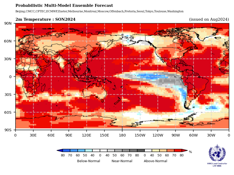
But all this is playing against a background of significant climate warming. The World Meteorological Organization notes that El Nino/La Nina is not the only climate driver. It is predicting warmer temperatures over all land areas and all oceans, besides the La Nina-impacted eastern Pacific.

As you’ll see from the World Meteorological Organiation chart below, that cooler weather is south of the Hawaiian Islands. Like most of the rest of the globe, we in the Hawaiian Islands have warmer than normal weather likelihood. 

The WMO also suggests rainfall for Hawai’i will likely be lower than normal from September through November 2024. 

Hotter and drier. Welcome to the future.

© Jan TenBruggencate 2024


 A global map shows temperature forecasts for Sep-Nov 2024, with most areas predicted to experience above-normal temperatures. A color legend indicates the range from below-normal to above-normal temperatures.

Monday, September 30, 2024

Navy: Targeting Ka'ula Island bird refuge weekly with bombs and guns would only result in "incidental" take

 The Navy’s new proposal to expand bombing and gunnery practice at Ka’ula Island seems insupportable, both morally and as a matter of federal law.

Here is the Draft Environmental Assessment that includes the Ka’ula impacts.

It expands potential military operations at the tiny island to 55 per year, more than one a week. That is on an island that is a designated state seabird sanctuary (established 1978) and contains endangered and state and federally protected plants and birds, and marine protected species in the nearshore waters.

Ka’ula is one of the four islands of of Kaua’i County (Kaua’i, Ni’ihau, Lehua and Ka’ula). The designated weaponry impact area is 11 acres at the southern end of the 130-acre island.

Ka’ula is well known in Hawaiian history and chant. The bird life there was once so dense that the island was used as an example of overcrowding. 

(Hā’iki Ka’ula I ka ho’okē a na manu. There is no room on Ka’ula, for the birds are crowding. –from ‘Ōlelo No’eau by Mary Pukui.)

It has been bombed since 1952.

The Navy over the years has steadfastly resisted calls to end its bombing, from fishermen, from U.S. Congress members, the U.S. Secretary of the Interior, from the Kaua’i County Board of Supervisors (1961) and Kaua’i County Council (1975), and from federal fisheries and wildlife officials.

And from the State of Hawai’i, whose attorney general in 1978 asserted the island belongs to the state. That conflict over ownership was not resolved, and state officials now say the ownership is contested but no recent efforts to assert state control have been reported.

Weapon strikes are proposed to be limited to the designated 11-acre “impact area.” But that has not always been the case: 1) A 1978 fisherman’s report saw bombs exploding both in the water and among seabirds; 2) The Draft EA says there are likely live munitions on the island outside the impact area; 3) On one occasion in 1965, bombs intended for Ka’ula landed on Ni’ihau, more than 20 miles away.

The new proposal says only inert weapons will be deployed in the future.

The birds and seals of Ka’ula, as well as passing whales and dolphins, are protected by the US. Migratory Bird Treaty Act, the U.S. Marine Mammal Protection Act as well as the island’s designation as a State of Hawai’i bird refuge.

The Draft EA proposes that the impact of bombing, gunnery exercises, helicopter landings and other activities are acceptable. There are Hawaiian cultural sites, including stone temples and habitation sites, but they are outside the designated impact zones and so, “impacts on cultural resources would be less than significant.” (Page 3-86)

The Navy’s legal justification for harming wildlife is contained in a federal law, the 2003 National Defense Authorization Act. It “gave the Secretary of the Interior authority to prescribe regulations to exempt the Armed Forces from the incidental taking of migratory birds during authorized military readiness activities,” the Draft EA says.

Based on that, the Draft EA argues that targeting a wildlife refuge and protected bird nesting site with bombs, shells and landing helicopters would result in takes that are merely incidental. The Draft EA says (Page 3-30) that the Department of Defense has a responsibility to minimize and mitigate its impacts. But it seems at least problematic to argue incidental and minimized when the wildlife refuge is the target.

The Draft EA argues that health, safety and noise are not issues because there are “no human sensitive receptors” nearby. This, of course, does not address the impacts on the health, safety or hearing of protected sooty terns, threatened black-footed albatross or endangered Hawaiian monk seals.

The Navy asserts that it owns Ka’ula. That position has long been challenged by Hawai’i.

The island was set aside by the Territory of Hawaii for use by the U.S. Department of Commerce under the U.S. Lighthouse Service in 1924 as a lighthouse reserve. Commerce conveyed it to the Coast Guard, which operated a navigational light there until 1947, when it was permanently shut down.

Instead of returning the island to the territory, the Coast Guard in 1952 authorized the Navy to conduct bombing exercises, apparently without the authorization of territory. 

Kaua’i County residents began regularly protesting the activity within a few years, at the behest of anglers who said the bombing was impacting birds, which the fishermen depended on to locate schooling fish.

U.S. Rep. Patsy Mink in the early 1960s urged the island’s inclusion in the Hawaiian Islands National Wildlife Refuge, and the Department of Interior started but failed to complete that inclusion.

The Navy rejected the Hawaiian ownership arguments, and in 1965, U.S. Rep. Spark Matsunaga reported that the Coast Guard had transferred its authority over the island to the Navy.

The comment period for this Draft EA is ending. Comments go to pmrf-lbt-ea-comments@us.navy.mil.

© Jan TenBruggencate 2024

Saturday, September 21, 2024

John J. Berger''s new climate book: A comprehensive approach to saving the planet

 The top-of-mind responses to the climate crisis tend to be few and simple.

Use less fossil fuel and switch transportation to electric vehicles, restore forests, recycle, eat less meat.

But a serious response requires a broad rethinking of everything about how we live on the planet. And that’s complex.

John J. Berger’s new book runs through a lot of the approaches that are already underway and makes recommendations for how to proceed. The book is Solving the Climate Crisis: Frontline Reports from the Race to Save the Earth.

Berger is the author of Climate Myths, Beating the Heat, Forests Forever and more. He is a noted environmental writer and climate policy expert, and in his latest book he conducts a comprehensive review of strategies to address our warming climate.

Some possible solutions are underway right now or at least starting. Manufacturing steel that doesn’t depend on massive fossil fuel inputs. Replacing oil-based products with ones made from plants. Electric and fuel cell aircraft.

There’s green concrete, new approaches to recycling, buildings that produce more power than they use, hydrogen cargo trucks and so much more.

There are examples of farmers who have turned problematic fossil-fuel-reliant businesses into thriving green enterprises that restore the soil and entrain carbon. He outlines the benefits of saving and expanding forests.

He reviews some of the geoengineering approaches, like sucking carbon out of the atmosphere, and seeding the skies with compounds that reflect solar radiation.

He takes a realistic look at the issues associated with decarbonizing planet-wide.

There’s clearly lots to be done at the legal, policy and international affairs levels, Berger writes. His to-do list starts with a national recognition that we are in an emergency, and that we need a National Clean Energy Transition Plan.

But it would all be so very costly, right? Maybe not.

“Various studies have found that a clean-energy transition would cost no more than 2 percent of gross domestic product in the United States,” Berger writes. He says he worries about the accuracy of those estimates, but even so, “that’s a pretty good deal, given all the other economic, environmental, and health benefits the United States would also receive.”

Berger’s book is a little overwhelming in its scope, but it’s well-written and anyone interested in how we need to approach this crisis will find lots to chew on. That, and some hope. It may be complicated, but it's possible, is Berger's message.

It does occur to me that, given the topic of the book, an actionable strategy for Berger would have been making the ebook dramatically less expensive than a paper copy of the book, but it’s close to $20 for the electronic version. Here, here, here and here are a some ways to find Solving the Climate Crisis.

© Jan TenBruggencate 2024

Friday, September 13, 2024

Polynesian voyaging driven by resource shortages

 A lot of the research into Polynesian voyaging looks at how it was accomplished and when, but less work has been done on why.

Why would groups of individuals, living in Pacific paradise islands, expend enormous treasure and energy to build great canoes and outfit massive voyaging missions?

The answers are coming.

This blog first looked into the issue in 2007.

That article reviewed a paper that suggested that sea level changes between 4,000 and 6,000 years ago, which created resource shortages, could have launched the Polynesians eastward into the Pacific from the islands near Asia.

And now, there’s new research that suggests a second period of resource shortages 1,000 years ago drove the final exploration phase—the one that led to the inhabitation of Hawai’i, Tahiti, the Marquesas, the Cooks, and eventually Rapa Nui and Aotearoa.

The suggestion is that a huge, multi-century central Pacific drought, from about AD 900 to 1200 drove settled populations out of the central Pacific and led them to locate new homelands that could feed expanding populations.

A team of Hawai’i, United Kingdom and New Zealand researchers in 2020 published a paper saying the signs of that drought can still be located in lake sediments in the Pacific Islands.

Their work answers that nagging question about Pacific voyaging: Why? Why would islanders in rich environments expend vast resources to build and provision voyaging canoes, and then sail into the uncharted ocean?

The paper’s authors are David A. Sear, Melinda S. Allen, Jonathan D. Hassall, Ashley E. Maloney, Peter G. Langdon, Alex E. Morrison, Andrew C. G. Henderson, Helen Mackay, Ian W. Croudace, Charlotte Clarke, Julian P. Sachs, Georgiana Macdonald, Richard C. Chiverrell, Melanie J. Leng, L. M. Cisneros-Dozal, Thierry Fonville, and Emma Pearson. Morrison is a senior archaeologist with Honolulu’s International Archaeology, LLC.

Their research paper, “Human settlement of East Polynesia earlier, incremental, and coincident with prolonged South Pacific drought,” was published in 2020 in the Proceedings of the National Academy of Sciences.

That prolonged drought was detected in sediments in Efate in Vanuatu, ‘Upolu in Samoa, and Atiu in the Southern Cook Islands. Other data from Tahiti and Kiribati also supports the drought hypothesis. It lasted from about AD 900 to AD 1200.

Their suggestion is that exploratory voyagers sailed out initially around 900, that they located islands and brought that information home, but that actual colonization took place generations later.

But once again, the message is that Polynesians voyaged because they had do.

© Jan TenBruggencate 2024

Monday, September 2, 2024

Voyaging: Nailing down when the first canoe pulled up on a Hawaiian beach.


Your grandfather might tell you otherwise, but it is increasingly clear that the first humans set foot in Hawai’i in the year AD 1000, give or take a few decades.

Archaeologists and other researchers have been honing on that period for a couple of decades as their tools have improved for determining the age of human-related activities and artifacts. Early, widely varying carbon-14 dates have been adjusted and refined, and several new technologies have been added to the tool kit.

This isn’t brand new information, but I still hear older Hawai’i people advocating for dates they remember being taught as little as 30 or 40 years ago.

Until and into the 1980s, the common assumption was that the Hawaiian Islands were first inhabited early in the first millennium after Christ, and a few folks still still argue for AD 500, 300 or occasionally even earlier.

In his seminal 1985 book Feathered Gods and Fishhooks, leading Pacific archaeologist Patrick Kirch reflected the wisdom of the period: “It is clear that colonization parties from the Marquesas were responsible for the settlement of Easter Island by about A.D. 400 and of Hawai’i by possibly by A.D. 300.”

But the science has improved much since then, and the errors of the early dating have been corrected. By the 2023 revision of Feathered Gods and Fishhooks, Kirch and Mark McCoy had moved the number to closer to 1000.

Why? Wrote the authors: “No one could have foreseen…the major technological advances that would come…the use of GPS and GIS in settlement archaeology, AMS radiocarbon dating and Bayesian modeling…high-precision dating of corals, stable isotope analysis of faunal remains or XRF geochemical analysis of stone artifacts.”

Professional archaeology now assumes there weren’t any humans in the eastern Pacific as early as CE 300 or 400. (Maybe a lost fisherman or an intrepid sailor who left no evidence.) It is more likely that Polynesian voyaging canoes around AD 900 began pushing—probably from the Samoa islands—into eastern Polynesia.

Why did those Polynesians voyage? There have been many theories, but one recent one is that they were driven out of their home islands by drought. David Sear and co-authors Melinda Allen, Jonathan Hassall and Emma Pearson said that drought may have lasted 200-400 years, certainly from before AD 900 to after 1100. 

Whether or not drought alone was enough to coerce people to abandon their homes, there’s an associated stressor. Population pressure would have been a big factor as expanding island families began outgrowing their small islands’ ability to feed them.

Science now generally presumes that on departure from the central Pacific islands, some of the eastern Pacific islands south of the Equator were populated first. Perhaps the Cook Islands, which are just to the southeast and downwind of Samoa. Then the nearby islands and finally then canoes came north to Hawai’i, east to Rapa Nui (Easter Island) and then west to Aotearoa (New Zealand.) The chronology could change with additional findings and new technologies.

But all of that voyaging may have occurred in a pulse of only a few generations. The voyaging canoes left Samoa around 900 and would have populated all those other islands within just a couple of hundred years.

“The archaeological and paleoenvironmental estimates of the colonization date show a striking convergence, indicating that initial settlement (of Hawai’i) occurred at A.D. 940–1130…and most probably between A.D. 1000 to 1100,” wrote pollen expert Stephen Athens and Timothy M. Rieth and Thomas S. Dye, in a 2017 article in the journal American Antiquity, entitled, “A Paleoenvironmental and Archaeological Model-Based Age Estimate for the Colonization of Hawai’i.” 

They cited updated radiocarbon dating and pollen from archaeological coring data.

One of the best resources for dating first human activity on Kaua’i was developed by David Burney and William “Pila” Kikuchi at Makauwahi Cave on the swampy south coast of the island. Their 2006 paper, based on flooded sediments in the cave floor, estimated first Polynesian activity at between AD 1039-1241. 

A lot of the earliest archaeological dates in Hawai'i are now settling in on that time period.

What is amazing, given the compressed period of Hawaiian occupation, is the extent of the great public works that were completed: the many hundreds of fishponds, the massive stone temples, the remarkable waterworks for flooded kalo fields and the vast dryland field agricultural systems.

© Jan TenBruggencate