Showing posts with label Wind. Show all posts

Wednesday, March 19, 2025

More and worse than ever: World Meteorological Organization new climate report

 There are those—some of them in our nation’s leadership—who still deny climate science.

It’s a little like rejecting the rain forecast when the flood is already up to your knees.

The World Meteorological Organization just issued its State of the Climate report. It is no longer about predictions, because the predictions of past decades are all now coming to pass.

 Here is the WMO press release about the report. 

Here is the actual WMO report. 

World atmospheric carbon-dioxide levels are the highest they have been in 800,000 years, and so are its fellow greenhouse gases methan and nitrous oxide.

Global surface temperatures are the highest they have been since records have been kept. Last year was the single hottest year on record, and the past decade is the single hottest decade on record. And it continues. January 2025 was the hottest January on record.

The oceans, which store massive amounts of heat, are hotter than ever. Each of the past eight years has been the hottest. Oceans take up 90% of the heat rise that is driven by greenhouse gas increases. Without the oceans taking up heat, the atmospheric temperatures would be even higher.

In part because of the heat, sea levels are rising faster than ever—both because warmer water takes up more volume and because glaciers are melting their stored water back into the sea.

The ocean is acidifying at a record pace—and changing the chemistry of the oceans will have significant effects. Says WMO: “The effects of ocean acidification on habitat area, biodiversity and ecosystems have already been clearly observed, and food production from shellfish aquaculture and fisheries has been hit as have coral reefs.”

All that warming and its impacts lead to weather disruptions, and the report says that extreme weather events in 2024 led to the highest level of human disruptions on record.

It takes all kinds of forms. One of them, for Hawai`i residents, is an ongoing drought that has produced the lowest stream flows since we started keeping records more than a century ago.

 The changes in climate also lead to reductions in food and fishery production, driving food insecurity on a global scale.

The severity of the climate disruption is such that the WMO is now more about responding to the chaos than stopping it. In the foreword to the report, WMO Secretary-General Celeste Saulo said this:

“WMO and the global community are intensifying efforts to strengthen early warning systems and climate services to help decision-makers and society at large be more resilient to extreme weather and climate. We are making progress but need to go further and need to go faster. Only half of all countries worldwide have adequate multi-hazard early warning systems. This must change.”

The World Meteorological Organization is a non-governmental international organizatioTn founded as a place where international researchers could share data. It was created in 1950, but is rooted in the International Meteorological Organization, which dates back to 1873.

It is not just WMO reporting this.

Here is NOAA’s report: https://www.ncei.noaa.gov/access/monitoring/monthly-report/global/202413

And here is the European Union’s Copernicus Program report: https://climate.copernicus.eu/global-climate-highlights-2024


© Jan TenBruggencate 2025
Saturday, October 12, 2024

As Florida cleans up from two hurricanes, Hawai`i is dodging the bullet. Instead, we get hot and dry.

 Hawai’i has benefitted in recent years from the lack of strong hurricanes, while the folks on the Atlantic coasts have taken multiple hits from big spinning storms.

Tropical storm activity can be cyclical. Sometimes it’s higher in the Atlantic; sometimes in the Pacific. That seesaw pattern has been linked to the El Nino Southern Oscillation, a climate pattern associated with ocean water temperature, air temperature, jet streams and rainfall patterns.

During El Nino events, warm water pushes into the eastern Pacific, and tropical cyclones are more likely and stronger in the Pacific. They call El Nino the warm phase. In La Nina, those waters are cooler, and the storm action moves into the Atlantic. They call it a cool phase.

Currently, we’re in a neutral period, but NOAA says we’re likely moving into another La Nina.

Back in May 2024, the National Weather Service predicted a lower-than-normal hurricane season for the Islands, anticipating that shift from neutral to a cooler phase. In a May 21, 2024 press release, NOAA reported:

“Hurricane season in the central Pacific region is likely to be below average this year,” said Matthew Rosencrans, lead seasonal hurricane forecaster at NOAA’s Climate Prediction Center, a division of NOAA’s National Weather Service (NWS). “A key factor influencing our forecast is the predicted arrival of La Nina this summer, which typically contributes to less tropical cyclone activity across the central Pacific Ocean basin.” 

So far, only Hurricanes Gilma and Hone, at the end of August, came near enough to Hawai’i to cause significant weather events locally.

Meanwhile, the Atlantic has been ravaged, pretty much as predicted.

Nine hurricanes in the Atlantic so far this year, four of them Category 4 or greater. The Eastern U.S. has been hit by two powerful and destructive cyclones in just the past month: Helene and Milton.

And the continuing transition into another La Nina does not bode well for the Atlantic coastlines.

With two months to the end of the hurricane season, Hawai’i can hold its breath with a little hope. A storm might come, but it’s less likely than average.

So what about next year? The latest NOAA El Nino forecast suggests the incoming La Nina will last into the beginning of next year. Beyond that, it’s hard to know what will happen.

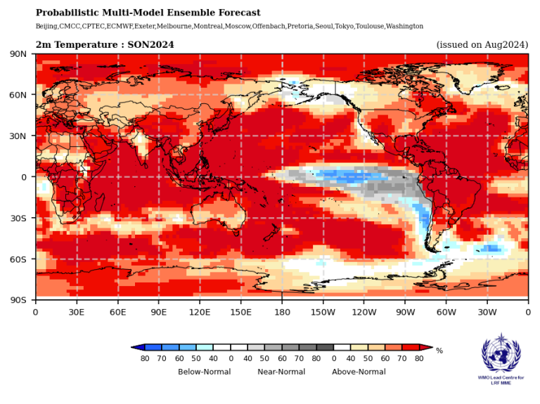
But all this is playing against a background of significant climate warming. The World Meteorological Organization notes that El Nino/La Nina is not the only climate driver. It is predicting warmer temperatures over all land areas and all oceans, besides the La Nina-impacted eastern Pacific.

As you’ll see from the World Meteorological Organiation chart below, that cooler weather is south of the Hawaiian Islands. Like most of the rest of the globe, we in the Hawaiian Islands have warmer than normal weather likelihood. 

The WMO also suggests rainfall for Hawai’i will likely be lower than normal from September through November 2024. 

Hotter and drier. Welcome to the future.

© Jan TenBruggencate 2024


 A global map shows temperature forecasts for Sep-Nov 2024, with most areas predicted to experience above-normal temperatures. A color legend indicates the range from below-normal to above-normal temperatures.

Monday, September 2, 2024

Voyaging: Nailing down when the first canoe pulled up on a Hawaiian beach.


Your grandfather might tell you otherwise, but it is increasingly clear that the first humans set foot in Hawai’i in the year AD 1000, give or take a few decades.

Archaeologists and other researchers have been honing on that period for a couple of decades as their tools have improved for determining the age of human-related activities and artifacts. Early, widely varying carbon-14 dates have been adjusted and refined, and several new technologies have been added to the tool kit.

This isn’t brand new information, but I still hear older Hawai’i people advocating for dates they remember being taught as little as 30 or 40 years ago.

Until and into the 1980s, the common assumption was that the Hawaiian Islands were first inhabited early in the first millennium after Christ, and a few folks still still argue for AD 500, 300 or occasionally even earlier.

In his seminal 1985 book Feathered Gods and Fishhooks, leading Pacific archaeologist Patrick Kirch reflected the wisdom of the period: “It is clear that colonization parties from the Marquesas were responsible for the settlement of Easter Island by about A.D. 400 and of Hawai’i by possibly by A.D. 300.”

But the science has improved much since then, and the errors of the early dating have been corrected. By the 2023 revision of Feathered Gods and Fishhooks, Kirch and Mark McCoy had moved the number to closer to 1000.

Why? Wrote the authors: “No one could have foreseen…the major technological advances that would come…the use of GPS and GIS in settlement archaeology, AMS radiocarbon dating and Bayesian modeling…high-precision dating of corals, stable isotope analysis of faunal remains or XRF geochemical analysis of stone artifacts.”

Professional archaeology now assumes there weren’t any humans in the eastern Pacific as early as CE 300 or 400. (Maybe a lost fisherman or an intrepid sailor who left no evidence.) It is more likely that Polynesian voyaging canoes around AD 900 began pushing—probably from the Samoa islands—into eastern Polynesia.

Why did those Polynesians voyage? There have been many theories, but one recent one is that they were driven out of their home islands by drought. David Sear and co-authors Melinda Allen, Jonathan Hassall and Emma Pearson said that drought may have lasted 200-400 years, certainly from before AD 900 to after 1100. 

Whether or not drought alone was enough to coerce people to abandon their homes, there’s an associated stressor. Population pressure would have been a big factor as expanding island families began outgrowing their small islands’ ability to feed them.

Science now generally presumes that on departure from the central Pacific islands, some of the eastern Pacific islands south of the Equator were populated first. Perhaps the Cook Islands, which are just to the southeast and downwind of Samoa. Then the nearby islands and finally then canoes came north to Hawai’i, east to Rapa Nui (Easter Island) and then west to Aotearoa (New Zealand.) The chronology could change with additional findings and new technologies.

But all of that voyaging may have occurred in a pulse of only a few generations. The voyaging canoes left Samoa around 900 and would have populated all those other islands within just a couple of hundred years.

“The archaeological and paleoenvironmental estimates of the colonization date show a striking convergence, indicating that initial settlement (of Hawai’i) occurred at A.D. 940–1130…and most probably between A.D. 1000 to 1100,” wrote pollen expert Stephen Athens and Timothy M. Rieth and Thomas S. Dye, in a 2017 article in the journal American Antiquity, entitled, “A Paleoenvironmental and Archaeological Model-Based Age Estimate for the Colonization of Hawai’i.” 

They cited updated radiocarbon dating and pollen from archaeological coring data.

One of the best resources for dating first human activity on Kaua’i was developed by David Burney and William “Pila” Kikuchi at Makauwahi Cave on the swampy south coast of the island. Their 2006 paper, based on flooded sediments in the cave floor, estimated first Polynesian activity at between AD 1039-1241. 

A lot of the earliest archaeological dates in Hawai'i are now settling in on that time period.

What is amazing, given the compressed period of Hawaiian occupation, is the extent of the great public works that were completed: the many hundreds of fishponds, the massive stone temples, the remarkable waterworks for flooded kalo fields and the vast dryland field agricultural systems.

© Jan TenBruggencate

Thursday, June 20, 2024

Are we seeing more flight turbulence, and is it linked to climate change? Yes and yes.

 We have seen numerous reports of airliners suddenly plunging hundreds or thousands of feet midflight.

And a fair amount of suggestion that atmospheric turbulence is the cause, along with some guesswork that turbulence is increasing due to climate change.

Could that be true? The answer seems to be, yes.

There does seem to be a fair amount of turbulence-related airline drama this year. Here is a review of one kind, clear-air turbulence. 

There is also thunderstorm-related turbulence, and other kinds.

In February 10, 2024, a United flight experienced “moderate turbulence” between Newark and Los Angeles. Several passengers were injured.  

On May 20, a Singapore Airlines flight experienced severe turbulence over Myanmar, which caused significant injury.

Also in May, a Qatar Airways flight between Dohar and Dublin was knocked around, apparently by turbulence May 26. 

To be clear, a review of many recent incidents of bumpy plane rides suggests that a lot of them have little or nothing to do with climate or turbulence.

An April 11, 2024, Southwest flight had a sudden drop while approaching Lihue Airport, leveling off at about 400 feet above the ocean. That, investigators said, was due to mistake at the controls by a pilot.

In a Latam Airlines incident in March 2024, a plane apparently went into a dive when the cockpit crew briefly lost control of the aircraft. The pilots brought the plane back into control. Latam called it a “a technical event during the flight which caused a strong movement.”

A 2022 United flight event involving a sudden drop was determined to be pilot error, according to the National Transportation Safety Board. 

In 2019, Psychology Today published an article about a Delta flight, on the fear generated by these kinds of events. 

In that case, the incident was a controlled descent apparently associated with a cabin pressurization event. The article decries media sensationalizing and mischaracterization.

But there are plenty of occasions when actual turbulence, rather than equipment or human error, are involved.

Hawaiian Airlines had such an incident in December 2022, 65 miles north of Maui. The National Transportation Safety Board report said, “A cloud shot up vertically (like a smoke plume) in front of the airplane in a matter of seconds, and there was not enough time to deviate.”  

No previous flights in the area that day had reported turbulence, but the NTSB report said: “Postaccident examination of the weather in the area revealed that there was an occluded frontal system with an associated upper-level trough moving towards the Hawaiian Islands. Satellite and weather radar imagery, and lightning data depicted strong cells in the vicinity of the flight.”

An article in Smithsonian Magazine argues that climate change may be causing increases in turbulence, and therefore in aircraft-involved incidents. 

U.S. Secretary of Transportation Pete Buttigieg in May said turbulence is increasing, and that climate change is a big factor. The Smithsonian article said that technology is also improving, and will help moderate risk, but that bumpier flights may be in our future.

Many of the injuries in such incidents involve people being thrown around the aircraft. It’s a reminder to keep those seat belts fastened.

© Jan TenBruggencate 2024

Monday, May 29, 2023

Hawai'i ocean levels inches below normal--what's going on?

 Sea levels around Hawai’i are unusually low, and have been for some months.

Experts aren’t sure why. They are pretty sure they’ll come back to normal, and higher. But because they’re not sure precisely why, they also can’t be sure when.

My canoe paddling clan in recent month has noticed that low tides have seemed really low. Like, mud flats where there’s normally water. Others may be seeing reefs where there's normally water. And seeing beaches bigger than they were last year.

To figure this out, I called Chip Fletcher, who didn’t know, but knew who would. Fletcher is the interim dean at the University of Hawai’i Mānoa School of Ocean and Earth Science and Technology. He’s the go-to guy on impacts of sea level rise in the Islands.

He suggested calling the university’s Sea Level Center, where associate director Matthew Widlandsky confirmed what we’d been seeing.

“You are right about the sea levels this year around Hawaii being lower than in recent years,” he wrote.

But while he and his colleagues have a theory about the reasons, nobody’s actually gone out and done the work to prove them. “We have not yet studied this event in detail,” Widlansky said.

One theory is that it’s associated with cooler water in the central Pacific, in connection with our just-ended three-year La Niña. Cooler water is denser, meaning it takes up less volume.

One of the several drivers of sea level rise is warmer water expanding, and this would be the reverse, a temporary situation in which cool water contracts.

But there might be more to it than just that.

We’ve experienced this kind of condition before in connection with El Niño (warm conditions) and La Niña (cooler conditions) climate cycles. A study in 2020 reviewed a 2017 period when we were having super-high tides.

Widlansky was a co-author of an article on that study, published in the Journal of Climate. Other authors were Xiaoyu Long, Fabian Schloesser, Philip R. Thompson, H. Annamalai, Mark A. Merrifield and Hyang Yoon.

“Hawaii experienced record-high sea levels during 2017, which followed the 2015 strong El Niño and coincided with weak trade winds in the tropical northeastern Pacific,” the authors wrote.

“During August 2017, the Honolulu Harbor tide gauge recorded the highest monthly average water level since records began in 1905.” That record was 17 centimeters, or more than half a foot higher than expected.

That said, high sea levels don’t always follow strong El Niño events, and didn’t after the strong 1997 event. So there’s something else also going on. Maybe winds. Maybe other stuff.

“The processes controlling whether Hawaii sea levels rise after El Niño have so far remained unknown,” they wrote.

In 2017, "the high sea levels were caused by the superposition, or stacking, of multiple contributions.”

The high sea levels associated with the 2015 strong El Niño lasted from 2016 until the end of summer in 2017, and then tapered off.

The current low water is just a couple of inches lower than normal, and it's different in different locations. 

It is not clear how long the current low stand of Hawaiian water will last. 

© Jan TenBruggencate 2023

Friday, March 10, 2023

Climate shifts further: La Niño is over, El Niño coming by summer

The La Nina oceanic condition, which we’ve been in for many months, has ended, and an El Nino appears likely to form in the summer or fall.

That’s the latest prediction from the Climate Prediction Center: 

It builds on the report we filed last month, when we suggested a fair chance of El Nino by mid year. That fair chance now seems to have been elevated to a pretty good chance. Spring predictions tend to be problematic, but most models see us going that way.

Thus the La Nina cool phase of Central Pacific climate is behind us, and we are in something called ENSO-neutral, ENSO being the term for the whole warm-cold cycle, El Niño Southern Oscillation.

Most climate prediction models now suggest we should shift into El Niño during the summer, and it might happen pretty quickly: “it is possible that strong warming near South America may portend a more rapid evolution toward El Niño.”

One of the things that can mean for Hawai’i is that we are likely to have a more active hurricane season. Also some other changes. More on that a little further down.

But one the questions that still challenges climate researchers is where climate change is taking the ENSO pattern broadly. There’s some suggestion that the past 40 years—since 1980—have been a little cooler than expected, a little more La Niña.

Now, many researchers say their models suggest the next few decades may swing toward more active El Niño conditions. But they don’t fully trust those models: the computer climate models of past climate don’t match up real will with actual observations of the climate. So how to be sure? A whole lot of smart people are working hard to make sense of that.  A discussion on this can be found at the ENSO blog

Among the variables: Warmer oceans can feed circulating storms, but warmer oceans and changing wind conditions can also cause changes in deep ocean upwellings. If they bring cool water to the surface from the deep ocean, then that could reduce the energy available to circulating storms like hurricanes. Changes in cloud cover could also create cooler surface conditions. And there are other variables.

“Heroic efforts are being done at modeling centers around the world to improve the representation of the physical processes,” wrote Kris Karnauskas, of the University of Colorado-Boulder.

That’s the long term.

For the coming year, what does an El Niño mean for us? There’s a nice NOAA fact sheet here. 

It suggests wetter weather at first, in late summer and fall, then drier. Maybe a dry winter this year. Weaker trade winds. More hurricanes and tropical storms. Warmer water around the Islands.

And sea levels slightly higher than normal, meaning big storm surf will reach farther inland.

All in all, interesting times.

© Jan TenBruggencate

Wednesday, February 22, 2023

Wrapping up the shot-down balloons story: Yes, balloons can crash planes

 We may not learn a whole lot more about the four objects shot down during February 2023 by American jets, other than they appeared to all be balloons carrying some sort of payload.

The first was a Chinese-owned giant balloon that drifted across North America from Alaska to North Carolina, where it was shot down February 4 after it passed the coast into the Atlantic. As best we know, it had surveillance equipment on board, multiple antennas, and presumably the capacity to track and report on U.S. communications. 

U.S. intelligence agencies tracked it from takeoff in south China, all the way to its downing off the Carolinas. We assume that we were able to gather significant intelligence from it while it operated, and more after most of it was recovered from the Atlantic. 

Three more balloons were shot down over the coastal ice in Alaska February 10, the forests of the Yukon in Canada February 11 and over the waters of Lake Huron February 12.

News reports indicate all three of them were most likely very small “pico balloons,” which are much smaller than the Chinese balloon, hard to track on radar, and which normally carry miniature payloads. One standard for these balloons is to carry transceivers that allow ham radio operators to communicate with them, or to transmit messages to them to be retransmitted to other radio operators.

None of the three small balloons was recovered, but an Illinois radio and balloon hobbyist group said the Canadian object was probably theirs.

The Northern Illinois Bottlecap Balloon Brigade said it might have been one of their mylar balloons, with the call sign K9Y0. It had been up for half a year, and had circled the globe nearly seven times. They don’t know for sure that the Yukon object, but they said it stopped transmitting about the time of the reported destruction of an object by a U.S. Fighter’s rocket. Aviation Week reported on it here. 

There may be dozens of similar balloons orbiting our planet at any time, on top of the weather balloons, corporate spy balloons, hot air balloons, party balloons, and nations’ spy balloons. In all, this Scientific American article says there may be hundreds to thousands up over the U.S. at any given time. 

Some have radio transponders so aircraft can detect them, some are reflective so they show up clearly on radar, but some are ghostly hard to detect, yet still dangerous to an aircraft that might suck one into its engine or around its control surfaces.

While plane-balloon interactions are rare, they have occurred. Most result in only minor damage to the plane, as when this Air Canada flight took out a weather balloon in 2019. https://simpleflying.com/air-canada-weather-ballon-collision.

But some have caused crashes.

Forty-five people were killed in a 1970s Russian crash after a propellor plane hit a weather balloon. 

In California in 1994, a twin-engine Piper Comanche went down, killing its pilot, after it apparently hit party balloons. 

In 2007 a Cessna lost a wing after hitting the tether line for an inflatable airship. 

And there are near misses, as when this Qatar Airlines Boeing jet managed to dodge a large balloon over Brazil last year. 

© Jan TenBruggencate 2023