Saturday, December 31, 2022

The volcanoes: Kīlauea reinflating, Mauna Loa resting

Two weeks after their double eruption, Kīlauea and Mauna Loa are handling the holidays differently, although neither is erupting.

Mauna Loa appears to be resting, according to the U.S. Geological Survey’s Hawaiian Volcano Observatory.

At Mauna Loa, “deformation rates have decreased significantly, and there is no sign of inflation at this time. The Hawaiian Volcano Observatory continues to closely monitor the earthquake and deformation rates at Mauna Loa. We expect additional shallow seismicity and other signs of unrest to precede any future eruption, if one were to occur,” the observatory reported.

At Kīlauea, there is more activity. Seismologists’ instruments show that Kīlauea is re-inflating, its upper area expanding as magma pumps into underground chambers near the surface.

The smaller mountain has been inflating since November 29—meaning it was inflating at the same time it was erupting during the early days of the Mauna Loa eruption. A seismic swarm, indicating magma movement underground, shook the volcano Friday (December 30).

“These earthquakes are typical as the summit of Kīlauea repressurizes after the end of the last eruption.  The earthquakes are generally dispersed beneath and around the south side of Halemaʻumaʻu,” the HVO reported.

It is normal for Mauna Loa to take a longer break between eruptions than Kīlauea.

Kīlauea’s most recent eruption lasted a little more than 14 months from September 29, 2021, to December 9, 2022. It was entirely within the crater at Halema’uma’u. The volcano erupts frequently, often a couple of times a year, and sometimes continuously for years.

Mauna Loa’s recent eruption lasted from November 27, 2022, to December 10, 2022. The volcano for the past couple of centuries has erupted every five years or so, but pauses between eruptions can be months to decades long.

© Jan TenBruggencate 2022

Thursday, December 29, 2022

How bad is the sea level rise scenario? It could hardly be worse.

The sea level rise issue in Hawai’i is getting worse, and it’s moving toward apocalyptic in a state that depends on its shorelines.

The risk varies around the country—higher on the East Coast than the West Coast and Hawai’i, but nevertheless scary high everywhere.

“Without additional risk-reduction measures, U.S. coastal infrastructure, communities, and ecosystems will face significant consequences,” says a National Ocean Service report.

It is no surprise our beaches are at risk and disappearing. Sea level is now rising at an inch every eight years. 

That means sea levels are now five inches higher than they were when a 40-year-old was born.

And since beach slopes are so low, five inches vertically can mean those beaches erode many dozens of feet inland. We’ve seen that.

It explains houses falling into the water in several Hawai’i locations. Why beach parks are shrinking. Why your beach walks, which used to be on dry sand, are ankle-deep at high tide and you’re dodging sandbags. Why some coastal features, including low-lying roads and harbor piers, are under water at high tide.

As time goes on, and older high-risk scenarios are confirmed, the more hopeful scenarios are necessarily being abandoned.

The sea level is not only rising fast, but it is rising even faster over time. It is now rising at more than twice the average rate during the 1900s. And the increase has continued and is likely to continue further.

You can review the latest data yourself at the 2022 Sea Level Rise Technical Report of NOAA’s National Ocean Service. 

It estimates Hawai’i sea levels in 30 years to be a little less than a foot higher than now. On a beach sloping at 1 percent, that means dozens to approaching 100 more feet of inland migration.

On highways that now get wave-washed at highest tides, it means erosion forces will be dramatic.

We could lose lateral coastal travel in some areas on several islands. Several Hawai’i coastal roads have already lost one of their two lanes due to eroded shores.

The technical report predicts that damaging high tide flooding will occur quarterly and monthly high tide flooding almost monthly.

It means that if you’re building anything on an eroding shoreline today, it’s unlikely to survive through the life of a 30-year mortgage without significant shoreline hardening.

“Sea level rise driven by global climate change is a clear and present risk to the United States, now and for the foreseeable future,” the report says.

© Jan TenBruggencate 2022 

Monday, December 26, 2022

Keeling Curve, key climate change measure, restored after Mauna Loa flow interuption


The Keeling Curve is back, after a brief volcanic interlude.

The world’s longest-running measurement of changes in carbon dioxide in the atmosphere is collected at a small observatory some 11,000 feet high on the slopes of Mauna Loa. It’s been tracking the changes since 1958, when Charles Keeling started taking the measurements.

The 2022 eruption of Mauna Loa sent a flow across the observatory access road and interrupted the Mauna Loa Observatory’s ability to operate on November 29. As the lava cooled, service was restored in mid-December.


(Images: The top image for the past month shows the interruption in the data. The image immediately above shows the full Keeling Curve, since 1958. Both are courtesy of Scripps Institution of Oceanographty at UC San Diego. Bottom image of the Mauna Loa Observatory is courtesy of NOAA.)

It’s not the first time Madame Pele has interfered with the science. She also did it in the 1984 Mauna Loa eruption.

“It’s in a bad place,” said Ralph Keeling, a geoscientist with Scripps Institution of Oceanography at the University of California San Diego. Ralph is Charles Keeling’s son.

A bad place from a volcanic risk view, but an excellent place for its unique kind of measurement—gathering atmospheric gas changes in the mid-pacific at an elevation high above most of the dust and pollutants of cities and streets.

The Keeling Curve has been a key scientific data point in the discussion of climate change, since carbon dioxide is one of the key atmospheric gases associated with the warming of our planet.

The observatory is operated by the National Oceanic and Atmospheric Administration.

The latest Keeling reading, Christmas Day 2022, was 419.25 parts per million CO2 in the atmosphere. That’s 50 percent higher than the level during the start of the Industrial Revolution in the 1800s, and more than 100 points higher than when Keeling first started taking measurements in 1958.

See the actual Keeling Curve measurements and read about the history of the measurement here

Yeah, and if you add CO2 data from ice cores, that 419.25 is higher than any Christmas since the first Christmas, and indeed, higher than any time in the last 800,000 years. This doesn't bode well.

© Jan TenBrugggencate 2022


Friday, December 23, 2022

Volcanic mystery solved: Mauna Loa and Kīlauea are connected 25 miles under Pāhala

 One deep mystery about our Hawai’i volcanoes has been solved.

The mystery was this: Do Mauna Loa and Kīlauea have independent connections to the hot rock in the Earth’s mantle, or do they share a magma reservoir nearer the surface.

Now, we know it’s the latter.

That’s due to a detailed study, reported in the December 22, 2022, issue of the journal Science. The study used artificial intelligence/machine learning to make sense of 3-D imagery of the locations of nearly 200,000 recent earthquakes under Mauna Loa and Kīlauea.

The study is entitled “The magmatic web beneath Hawai‘i.” It was written by John D.Wilding, Weiquiang Zhu, Zachary Ross and Jennifer Jackson. 

All of Hawai’i’s volcanoes are ultimately fed from the planet’s mantle, which is hundreds to a couple of thousand miles below the surface. They are fed by a phenomenon that has been called a Hot Spot, which drives molten rock from the deep mantle through cracks in the Earth’s crust, eventually to the surface.

The seismic study found that there is a magma storage area about 25 miles down, roughly under the Hawai’i Island town of Pāhala.

It takes the form of a series of horizontal structures, like stacked plates. These plates are roughly 3-4 miles wide, 1,000 feet thick, and vertically separated by about 1,500 feet of rock. The researchers call it the Pāhala sill complex.

From there, independent channels lead to the summit of Mauna Loa and the top of Kīlauea. The Mauna Loa channel is comparatively direct, while the Kīlauea channel goes laterally for a while, then rises to what looks like a secondary magma storage area 6-9 miles under the Kīlauea summit.

These channels are identified in the research as “seismicity bands,” which are areas, when mapped in 3-D, that show the location of pathways where magma may be moving.

So, yes, it looks like the two volcanoes are connected. But the magma feeding the two of them comes from different parts of the Pāhala sill complex, far enough apart that they sometimes seem to act independently.

So what about the newest Hawaiian volcano, Kama’ehuakanaloa (formerly Lō’ihi)? It does not seem to share the Pāhala sill complex, and appears to have its own route from the mantle, the authors write.

Star-Advertiser reporter Timothy Hurley’s review of the study here. 

National Geographic’s report on the study is here. 

© Jan TenBruggencate 2022

Tuesday, December 13, 2022

Eruption over, both Kīlauea and Mauna Loa pau


The storied double eruption of Kīlauea and Mauna Loa is over, with the official notice today, December 13, 2022, that both eruptions have stopped.

The cessation was not quite simultaneous, but close.

The Hawaiian Volcano observatory has moved both volcanoes off its orange alert level to yellow, and has issued these relevant statements:

“Kīlauea is no longer erupting. Lava supply to the Halemaʻumaʻu lava lake ceased on December 9 based upon lava lake levels and behavior of the crater floor. Sulfur dioxide emissions have decreased to near pre-eruption background levels.” 

“Mauna Loa is no longer erupting. Lava supply to the fissure 3 vent on the Northeast Rift Zone ceased on December 10 and sulfur dioxide emissions have decreased to near pre-eruption background levels. Volcanic tremor and earthquakes associated with the eruption are greatly diminished.”

© Jan TenBruggencate 2022

Sunday, December 11, 2022

Mauna Loa quiet, but maybe not done erupting


Things are confusing atop Mauna Loa.

There is no longer any fresh lava erupting anywhere on the surface of the mountain, either at the summit where the eruption started, or on the Northeast Rift Zone, which produced the flow that threatened the Saddle Road.

The major source of lava flows, Fissure 3, is no longer producing molten rock.

The entire surface area where new lava erupted since the eruption began November 27 is cooling down.

The measurable tremor under the summit, which indicates magma is moving underground, appears to have stopped.

Sulfur dioxide gas production is way down.

That would all suggest that the eruption is over.

But USGS’s Hawaiian Volcano Observatory is cautious.

“The Northeast Rift Zone eruption of Mauna Loa may still be active,” it said in its Sunday (December 11, 2022) update.

One data point: The summit is once again inflating.

“The significance of the continuing inflation while the flow field is inactive is not yet clear,” the scientists said.

In past eruptions, once a shutdown like this has occurred, Mauna Loa hasn’t been seen to return to big time eruption, but it might, or it might return to something less than that. Or it might be done.

As we’ve been doing, we wait.

© Jan TenBruggencate 2022

Saturday, December 10, 2022

Lose the mosquito, save the bird, save the forest.

 Haleakalā National Park hopes to launch a program to protect the park’s few remaining native forest birds from the ravages of avian malaria.

And maybe save our native forests in the process.

This mosquito-borne disease is a primary cause of the loss of our state’s stunning forest singers—all the green and gold and red and brown and slate feathered gems, with their flashing tufts and perky tails and dramatically curved beaks.

The combination of a new sterile mosquito technique and recent advances in drone technology mean this control program is something whose time has just come.

The park has released for public comment its environmental assessment, “Suppression of Invasive Mosquito Populations to Reduce Transmission of Avian Malaria to Threatened and Endangered Forest Birds on East Maui.”

It is available here, along with an opportunity to comment. (I’ll be clear: I have commented in favor of the program and strongly support it.) 

The proposal, in short, is to use drones to release sterile male mosquitoes that have been infected by a natural bacterium called Wolbachia. The males will outnumber natural males, and when they mate with females, no young are produced. That will reduce mosquito populations and presumably reduce new infections with avian malaria.

The Incompatible Mosquito Technique in this case would be aimed at the southern house mosquito (Culex quinquefasciatus), which is the only Hawai’i-resident mosquito to transmit avian malaria.

This disease has wiped out dozens of species of amazing Hawaiian forest flyers, many of which were specialized pollinators of rare native plants—so the entire forest dies with them.

The technique has been used elsewhere on other mosquito species to control diseases like dengue fever.

The World Mosquito Program reported earlier this year: “We have released Wolbachia mosquitoes to reach more than 10 million people (as of June 2022). In areas where Wolbachia is self-sustaining at a high level, notified dengue and chikungunya incidence has been significantly reduced.”

The World Mosquito Program reviews the technology here. https://www.worldmosquitoprogram.org/en/work/wolbachia-method

We’ve been talking about it in Hawai’i for several years. Talented writers Brittany Lyte and Nathan Eagle reviewed progress in Honolulu Civil Beat three years ago. 

The park has been holding public meetings on the program even before the draft environmental assessment was released. The environmental assessment comment period runs to January 23, 2023.

And to be clear, there have been lots of programs to control mosquitoes over the decades, and they have included various pesticides, repellents, genetic modification, fungi and now bacteria. Lots of older folks, me included, can remember running in clouds of DDT that were used to control insect pests a couple of generations ago.

How far we’ve come.

© Jan TenBruggencate 2022

Mauna Loa is like "Jaws." Something's moving below the surface. When will it rise?


(Image: Webcam shot at Mauna Loa's Fissue 3, taken this morning, December 10, 2022. Credit: USGS.)

The Mauna Loa eruption right now is a little like the movie Jaws: something's moving under the calm surface...when will it rise?

The eruption that started November 27 has stopped producing much lava. Its threat to the Saddle Road is, for now, abated. It's not fountaining any more. There's just a pond of lava at the Fissure 3 vent, which is spilling over into short, stagnating flows. Significantly less gas is being pumped out of the fissure.

But deep below, magma is still moving up into the upper reaches of the mountain. 

"Tremor (a signal associated with subsurface fluid movement) continues beneath the currently active fissue," the USGS reported this morning,

"This indicates that magma is still being supplied to the fissure and activity is likely to continue as long as we see this signal."

Yesterday, the USGS suggested the fountaining could return any time, Today, the scientists downplayed that possibility: "None of the eight recorded eruptions from Mauna Loa's Northeast Rift Zone returned to high eruption rates after those rates decreased significantly." 

So the magma is still rising underground, but it's not erupting. 

Hmm. Can you hear the "Jaws" drumbeat?

© Jan TenBruggencate 2022


Friday, December 9, 2022

Quiet on the Mountain: Mauna Loa in a pause? Not quite.


Things are pretty calm up on Mauna Loa, with the active fissure glowing, but not aggressively fountaining, and still apparently producing a little lava.

It will be some time before it is clear what's going on, whether this is the start of a pause in the Mauna Loa eruption, or the end of this event, or something entirely different.

"A return to high levels of lava discharge could occur," the USGS said in its Friday morning update.

The image above is a USGS webcam view of Fissure 3, which until two days ago was pumping with high lava fountains and feeding a long flow that threatened the Saddle Road/Daniel K. Inouye Highway. The image was collected at 8:36 a.m. Friday, December 22, 2022.

There's still some glowing rock, but fountains are not visible in this image. The USGS update late Thursday indicated that the amount of lava had dropped significantly from Wednesday to Thursday. And this morning it reported that there was low fountaining that was feeding a small flow that goes a mile or so from the vent.

The long flow that got to within 1.7 miles of the highway is essentially stopped, although as it cools, it is spreading out a little.


An image from a webcam a few minutes later overlooking Moku'aweoweo  indicated the summit caldera was similarly quiet.


Another webcam shot from Mauna Kea, looking across to Mauna Loa at 8:36 a.m. shows smoke up on the Mauna Loa rift zone, but no fire.

View the webcam images yourself here.

What does it all mean? The Hawaiian Volcano Observatory scientists admit they're not certain.

"The significance of the reduced supply of lava is not yet clear; it is common for eruptions to wax and wane or pause completely," the USGS reported in its morning update.

It reported that there is still magma moving up into the mountain, as indicated by continuing tremor within Mauna Loa.


© Jan TenBruggencate 2022

Thursday, December 8, 2022

Mauna Loa eruption scaling back


The Saddle Road appears safe for now from being engulfed in lava.

Mauna Loa dramatically reduced its eruption lava volume overnight from December 7 to 8, and is no longer feeding the long flow that had threatened the Daniel K. Inouye Highway. The flow front is stalled and cooling about 1.7 miles from the highway. 

The USGS reported: "Lava is overtopping channels near the vent with flows extending no farther than 2.5 mi (4 km) from the vent. The channels below this point appear drained of lava and probably no longer feed the main flow front."

That said, tremor measuring the flow of magma under the volcano indicates there's still molten rock being fed to the mountain.

So what happens next? We'll see.

See the full USGS report here.

© Jan TenBruggencate 2022


Hurricane season 2023 could be more dangerous


Hurricane seasons have brought mild weather for several years now, and the latest forecast suggests that El Nino will not return, at least through April 2023.

But there seems to be roughly an even chance of El Nino conditions showing up for the start of the 2023 hurricane season—the summer of 2023.

Forecasting that far out is fraught, so the Climate Prediction Center’s latest formal forecast, issued December 8, 2022, does not carry all the way into the 2023 Hurricane season. But there are indications that the climate may be shifting in the direction of El Nino.

Forecasters predict a roughly 50% chance that 2023’s hurricane season will have El Nino warming conditions, which are associated with more and stronger hurricanes for the Hawaiian Islands.

For many months, we have been in a La Nina ocean condition, which reflects cooler mid-Pacific waters less likely to promote hurricane development. Today’s prediction suggests there’s an even chance that through April 2023—the non-hurricane season--it will remain La Nina or neutral.

That said, there are indications the climate could be swinging in a warmer direction.

“In November 2022, negative subsurface temperature anomalies weakened, reflecting an eastward expansion of the above-average subsurface temperatures in the western and central Pacific and contraction of the below-average temperatures across the eastern Pacific,” the CPC/National Centers for Environmental Prediction said in its El Nino/Southern Oscillation Diagnostic Discussion

El Nino conditions have warmer waters around the Equator in the Pacific, and are associated with more and stronger hurricanes in the Central Pacific.

© Jan TenBruggencate 2022

Wednesday, December 7, 2022

Is the Saddle Road toast?

 The Saddle Road is toast.


A photo from earlier in the eruption, from an overflight the morning of November 30, 2022.  USGS image by K. Mulliken. 


I don’t hear a lot of folks talking about it, but the way the Mauna Loa eruption is going, the cross-island Daniel K. Inouye Highway within days will be impassable going east and west.

That has huge implications for passenger and supply transport between the Hilo side of Hawai’i Island to the east, and the Waimea and Kona side to the west. But it also has import for high-elevation science.

The main lava flow has already cut off access to the critical scientific center, Mauna Loa Observatory, and on its current course, it also has the potential to shut down access to the massive astronomy facilities at Mauna Kea. 

Judging from the topography, the east-west access will be gone before Mauna Kea access is threatened.

Mauna Loa may do what the Mauna Kea protests could not.

Mauna Loa’s eruption is currently focused on the northeast flank. A feature called Fissure 3 is feeding a long lava flow headed northward into the saddle between Mauna Kea and Mauna Loa.

It is in familiar territory for Madame Pele, with a 1935 flow on its right flank and an 1843 flow on its left. Both of those flows crossed the current route of the Daniel K. Inouye Highway.

The 1935 flow pooled in the saddle for a few days, then turned east and headed downslope for Hilo. The Air Force in late December 1935 bombed that flow to try to protect Hilo. Ultimately, that eruption stopped before Hilo could be impacted. Here is a National Park Service story on that.  

It lasted from November 21, 1935 to January 2, 1936. Eight weeks. 

The 1843 flow lasted three months.

This eruption started November 27, 2022, and shows no signs of stopping. The lava is now on pretty flat ground, less than two miles from the highway, and creeping forward at give-or-take 1,000 feet per day. But that could change.

The Hawaiian Volcano Observatory reports: “Lava flow advance rates may be highly variable over the coming days and week. Lava flows advance more slowly, spread out, and inflate on the flat ground between Mauna Loa and Mauna Kea. Individual lobes may advance quickly, and then stall. Additional breakouts may occur if lava channels get blocked upslope. There are many variables at play, and the direction and timing of flow advances are expected to change over hours to days, making it difficult to estimate when or if the flow will impact Daniel K. Inouye Highway.”

Realistically, things that can save the highway from being overflowed are an early stop of the eruption, or the activation of an entirely new fissure that allows the current flow to cool and harden in place.

© Jan TenBruggencate 2022

Tuesday, December 6, 2022

Volcanic pyrotechnics: Mauna Loa is back


It’s been a while since the night sky over the highest parts of Hawai’i Island were lit bright orange by something other than the sun.


(The image above, an aerial USGS photo taken early Dec. 6 by L. Gallant, displays fountains at Mauna Loa Fissue 3. The fountains are running at 40 meters on average, with bursts to 100 meters.)

The new eruption of Mauna Loa is filling those skies—and the internet—with stunning shots of blazing fountains, glowing clouds and sinewy Halloween-colored lava flows.

Mauna Loa took a pause after its two-volcano show with Kīlauea in 1984. It was a long pause by Mauna Loa standards. The big volcano—the biggest one in the world—has erupted every five years or so since the early 1800s, and once every 6 years over the last few millennia. So a 38-year quiet is quite something.

There used to be arguments among volcano folks about whether the underground plumbing made it even possible for Mauna Loa and Kīlauea to erupt at the same time. They did in 1984, and again now, so that’s settled. They generally do not erupt together, but they can.

The new mystery is whether it’s possible for Mauna Loa, Kīlauea AND the younger volcano Kama’ehuakanaloa to erupt at once. As far as we know, that has not yet happened.

Kama’ehuakanaloa, formerly known as Lō’ihi, lies in the waters 20+ miles east of Nā’alehu. It is not currently erupting, although occasional swarms of earthquakes show that there’s magma moving under that seamount. We’ll see.

And might it be possible for concurrent eruptions of those three plus Hualalālai, which last erupted in 1801, and isn’t done yet. Mauna Kea and Haleakalā eruptions are also possibilities, but all three seem to be geologically napping at this time.

Mauna Loa’s eruptive phases tend to be big shows, but short ones. They range from a few days or weeks to as much as a year. That’s short compared to Kīlauea’s, which can go on for decades, but which produce far less lava.

Mauna Loa’s flows can run to the sea very quickly down sloping ground, depending on the direction they take. During the past two centuries they have reached the shoreline in North Kona, South Kona and Ka’ū, and made it to the outskirts of Hilo. Mauna Loa flows have reached from the eruption site to the coast, tens of miles away, in as little as a few hours.

That’s not happening right now, largely because the 2022 eruption is currently flowing into the flattish lands of the saddle between Mauna Loa and Mauna Kea, but if the eruption continues, and the lava spills out into steeper slopes, it could get moving pretty quickly.

As this is written, the hot lava is less than two miles from the old Saddle Road, now the Daniel K. Inouye Highway. If that cross-island artery is cut, disruptions for residents will be significant.

Mauna Loa’s lava production has been estimated at an estimated 100 cubic meters per second. (By my calculations, that would fill an average Hawai’i house every couple of seconds, an average apartment building every couple of minutes.)

 If you’re interested in this eruption, the National Park Service has an information site here, and it includes lots of links to other sources of information. 

© Jan TenBruggencate 2022

Wednesday, February 16, 2022

At Palmyra, native forests store more carbon than coconut plantations

There are lots of interesting things about native forests in the Islands, and The Nature Conservancy has just added an important one.

These forests do a better job of capturing carbon than planted forests, at least in the example of Palmyra Island, where the Conservancy and the U.S. Fish and Wildlife Service operate an atoll refuge a few hundred miles south of Hawai’i.

Native Hawaiian forests are excellent at capturing moisture and preventing aggressive, eroding runoff. That is in part due to the complexity of the Hawaiian forest. There are generally canopy trees, and smaller understory trees and shrubs and at the lowest level, ferns and mosses.

So when a heavy rain falls, its downward force is diminished by all the leaves and branches it encounters on the way down, and then the forest soaks it up like a sponge. So mountain streams in native forest areas run clear, not muddy. And they keep running even after weeks of dry weather, as the natural spongy forest floor lets the water seep out slowly.

By contrast, in a forest dominated by alien trees, like eucalyptus or Java plum, there is little understory growth. And heavy rains often lead to muddy runoff, eroded gullies, and sediment-filled streams. And shortly after the rain stops, the soils dry out.

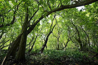
(Image at right: Pisonia forest at Palmyra. Credit: Andrew Wright.)


A new study at Palmyra by The Nature Conservancy has shown that another benefit of native forests is that they also store more carbon than single-species forests like the coconuts that once dominated Palmyra’s coralline ground.

The paper was published in PLOS One by Kate Longley-Wood, Mary Engels, Kevin D. Lafferty, John P. McLaughlin and Alex Wegmann. The title: Transforming Palmyra Atoll to native-tree dominance will increase net carbon storage and reduce dissolved organic carbon reef runoff.

At Palmyra, the Conservancy has been replacing dense coconut stands, which are not native to the island, and were planted to promote a copra industry, with the native forest that once existed there.  They knew there would be impacts of this conversion, but it wasn’t entirely clear what they would be.

“To better understand how this landscape-level change will alter the atoll’s carbon dynamics, we used field sampling, remote sensing, and parameter estimates from the literature to model the total carbon accumulation potential of Palmyra’s forest before and after transformation,” the authors wrote.

Their research showed that the new forest increased carbon storage on the atoll’s land areas by nearly 12 percent, and also reduced the flow of dissolved organic carbon into the island’s lagoon. That, in turn, is expected to result in healthier corals and a strong community of the species reliant on the coral reefs.

“We’ve demonstrated that better stewardship of natural resources can increase their carbon capture ability,” said lead author Kate Longley-Wood, Ocean Mapping Coordinator with TNC’s Protect Oceans, Lands and Waters program. “That native tree species are better for carbon capture and ocean health is the icing on the cake.”

All that said, it takes time for the effect to be seen, and the story will likely change somewhat over time as the restored forest matures. There is a loss of carbon in the standing trees when the coconuts are cut down and allowed to be replaced by native Pisonia grandis (Pu’atea in Tahitian or cabbage tree in English), Heliotropium foertherianum (beach heliotrope), Pandanus tectorius (hala or screwpine) and other species native to the atoll.

The native species are considered to be superior habitats for native seabirds, they store more carbon, and they support a larger native ecosystem.  But the results don’t mean it’s appropriate to go around cutting down all the coconuts elsewhere, as they could be important parts of the human communities on some islands. The scientific name of coconut is Cocos nucifera, sometimes written C. nucifera.

“C. nucifera’s role in human migration and settlement throughout Oceania is notable, and control of C. nucifera to transform native forest should be balanced with the societal value provided by C. nucifera to Pacific Island communities,” the paper said.

© Jan TenBruggencate 2022